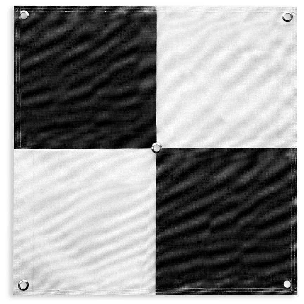
Sky High Bull's-Eye (24"x24") Drone Ground Control Point GCP - UAV Aerial Target for Mapping & Surveying (6 Pack) | Center Ey
4.8 | 48 ratings
Price: 59.99
Last update: 05-16-2026
About this item
- 24”x24” AERIAL TARGETS - Designed for low to medium altitude drone mapping and scanning, these drone GCPs were made for drone mapping up to 400 feet. The standard 24”x24” size is useful when scaling and verifying the map, providing a standard reference distance during post-processing.
- DRONE GCP WITH CENTER EYELET - The center eyelet design allows the user to easily identify the center of the GCP with a survey rod without tearing the aerial target. The center eyelet can also be used to position the aerial target directly over existing survey nails for precision mapping with existing ground control points.
- LIGHTWEIGHT & DURABLE AERIAL TARGETS - Using a weatherproof mesh material, these aerial targets were made to be highly visible yet lightweight, a big benefit when traveling or placing the ground control points in the field. The material is made with a matte finish which reduces glare from sunlight and overexposure on sunny days, which makes selecting the center of the target easier during post-processing.
- GCP WITH SOFTWARE COMPATIBILITY - These GCPs with the checkerboard pattern are compatible with many popular photogrammetry reconstruction software from the leading companies in the space drone mapping, photogrammetry, and surveying space. The GCPs are compatible with most auto-detection software, especially the software that auto-detects the checkerboard pattern aerial targets. These GCPs have been used in a wide range of industries and educational training programs with great success.
- UAV GCP WITH CORNER ANCHOR POINTS - With eyelets at each corner to easily anchor the aerial targets, the corner anchor points prevent the GCPs from moving during mapping. The anchors also allow the GCPs to be left in the field if needed for repeat flights over a period of time, providing peace of mind that the aerial targets offer repeatable location data for high-accuracy mapping and photogrammetry.
Product information
Technical Details
| Product Dimensions | 24 x 24 x 0.2 inches |
|---|---|
| Item Weight | 1.8 pounds |
| Manufacturer | Willis Worxs |
| ASIN | B07GGMM8LW |
| Is Discontinued By Manufacturer | No |
| Date First Available | August 14, 2018 |
Additional Information
| Best Sellers Rank |
|
|---|
Feedback

Sky High Bull's-Eye (24"x24") Drone Ground Control Point GCP - UAV Aerial Target for Mapping & Surveying (6 Pack) | Center Eyelet (Black/White Markers) | Pix4D & DroneDeploy Compatible
Share:https://www.amazon.com/dp/B07GGMM8LW
Found a lower price? Let us know. Although we can't match every price reported, we'll use your feedback to ensure that our prices remain competitive.
Where did you see a lower price?
Fields with an asterisk*are required
Pleasesign into provide feedback.
Top reviews from the United States
- Robert V. Johnson Jr.Good target. Well made. Shows well in data.As described. A little expensive, but well made and they show well in data with a decent quality sensor. Good for LiDAR and photogrammetry. Tough to fit in associated carry bag that I bought separately by the same brand for this set. Glad I went with 48” over 24”.
- Tyler BUAS&Manned Aerial Survey TargetsI’ve purchased hundreds of these for our remote sensing projects. Great quality and fast shipping. We prefer the 48x48 because it’s easier to see in the LiDAR data. I wish they would do away with the center eyelet and make it triangular flaps to the center. That’s what I normally have to rip out the second I get them so my nail doesn’t get disturbed picking them back up.
- SWG - Columbus, OhioExcellent tool for drone mappingProfessionally, I am a Civil Engineer and I like to use drone technology for mapping. I had a personal mapping project of my property where I wanted to track some progress of trail construction and align it with my property boundary.
I was able to situate these at multiple property corners, fly my drone over the area for mapping and clearly see these targets on the ground; even in wooded areas (flew in the winter with no leaves).
These specific targets do not have the larger center hole for property pin centering, but what I did was put the 'numbered' square corner up to the center of the pin and then staked down my corners to hold the target firmly in place. This allowed me to fly the property and know that the numbered squares are the corners - which is a consistent way to align the map with my boundary survey.
I flew at 185 ft (1.5cm/pixel for DJI Phantom 4) - I have trees I have to clear and 190' of topographic relief on the property). The numbers were very easy to read at this elevation. Since my 185' was fixed, down in the low points of the property, I was over 350' of elevation delta between the drone and target - still readable! I then flew at 235' feet (2cm/pixel) and still readable - at over 400' in elevation to the target. This target was also in a wooded area.
The targets are durably made. I can see them lasting for a lot of uses. I can also see that if a construction company wanted to monitor a job site over a period of time, these can likely withstand staying in the field for a few months - they might fade under UV light based upon the material type; but they are inexpensive to replace. You can possibly stake these down with better stakes - or mount to a hard surface with fasteners and even have an elevation target to use.
Overall - if you are doing drone mapping, these are a better tool than some of the 'homemade' solutions - especially at the price of plywood materials and paint; I would definitely recommend them. They are inexpensive solutions that provide reasonably accurate results. - Seth FordGreat product!Love these targets! Haven’t frayed, ripped, or become less useful in any way. Used roughly under land dev work and still performs. Good ad hoc takeoff/landing pads, too.
- Kent McIntireGood. Blows away.Works well for what I need it for. Very lightweight and blows away in the lightest of winds.
- Techtester1Good targets for RTK requirementsVery sturdy and well thought out.
- Jim W.AwesomeSturdy and Well Made. Very legible from the air. Each square is exactly 2 ft wide with each color in the square exactly 1 foot wide. Thus if you lay 5 side by side it makes a 10 foot scale for measuring in photos. Used them for planning landscaping with drones.
- Amazon CustomerFast deliveryPerfect delivery and quality