Sky High Bull's-Eye Disposable Ground Control Points (GCPs)/Aerial Targets for Aerial Mapping & Surveying (100 Pack) with Cen
4.8 | 265 ratings
Price: 119.99
Last update: 04-11-2026
About this item
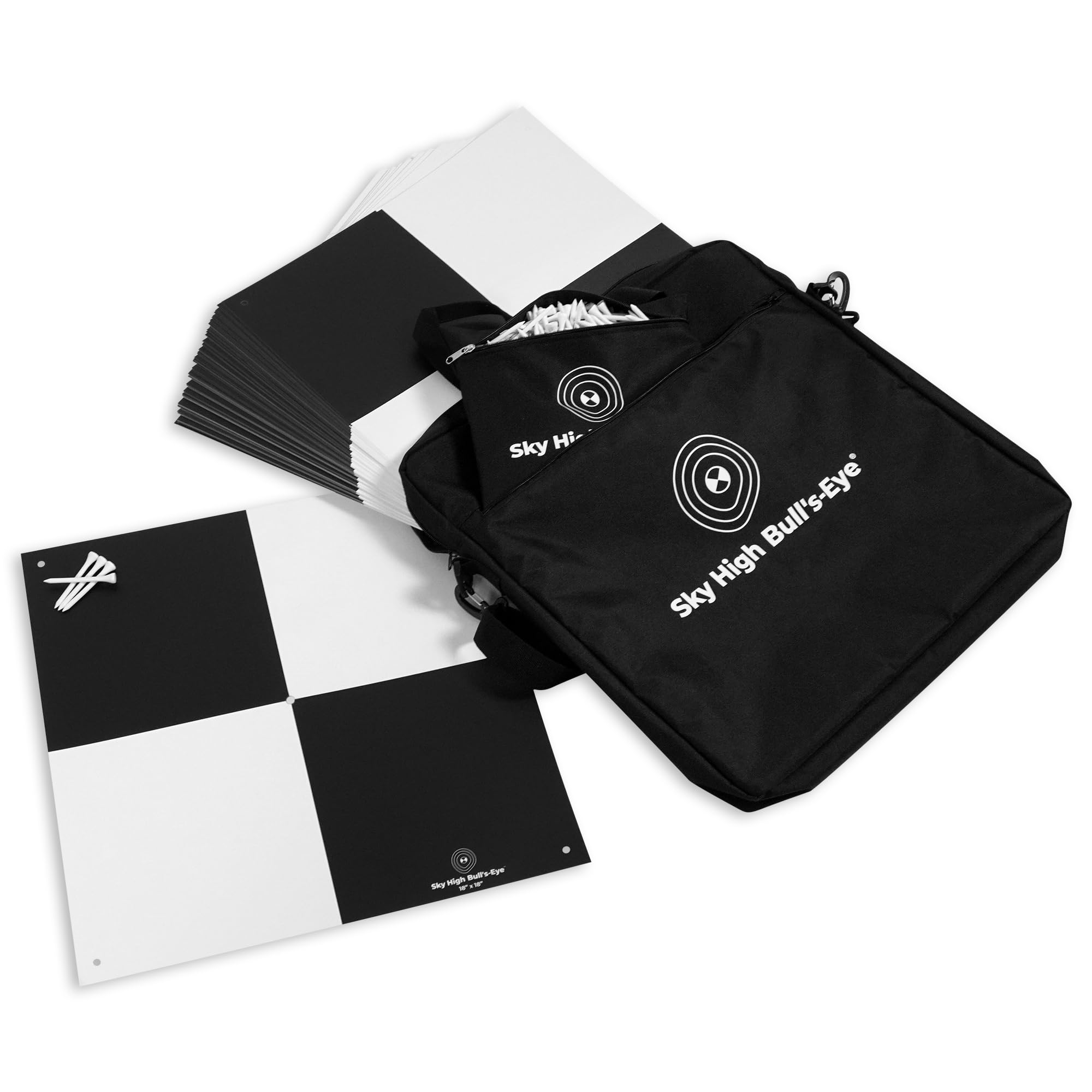
- PERFECT SIZE - 18" x 18" disposable aerial targets with a matte finish reduces glare from the sun and maintains high visitbility for your ground control point (GCP) needs
- BLACK & WHITE - Standard black and white checkerboard pattern is compatible with most photogrammetry software such as Pix4D, DroneDeploy, and other software with autorecognition features
- CENTER HOLE - Use the center hole for aligning measurement equipment for precision mapping without causing creases and tears in the drone target so that you can get accurate ground control readings for your drone mapping
- 60D NAILS & MAG SPIKE COMPATIBLE - The center hole is now compatible with 60D nails & 3" Mag Spikes for ease of use when establishing your ground control
- ECONOMICAL - With a low unit cost per GCP, this set of 100 aerial targets/ground control points (GCPs) are a great alternative to many DIY solutions commonly used in the industry
Product information
Item details
| Brand Name | Sky High Bull's-Eye |
|---|---|
| Target Audience | Unisex |
| Included Components | GCP Targets, Wooden Stakes, Wooden Stakes Bag, and Carrying Bag |
| Number of Sets | 1 |
| Manufacturer | Willis Worxs, LLC |
| UPC | 850012878537 |
| Global Trade Identification Number | 00850012878537 |
| Unit Count | 100.0 Count |
| Best Sellers Rank |
|
| ASIN | B0CJFZPLZZ |
| Customer Reviews | 4.84.8 out of 5 stars(265) 4.8 out of 5 stars |
Feedback

Sky High Bull's-Eye Disposable Ground Control Points (GCPs)/Aerial Targets for Aerial Mapping & Surveying (100 Pack) with Center Hole (18” x 18”) - Bonus Bag & 500 Stakes Included
Share:https://www.amazon.com/dp/B0CJFZPLZZ
Found a lower price? Let us know. Although we can't match every price reported, we'll use your feedback to ensure that our prices remain competitive.
Where did you see a lower price?
Fields with an asterisk*are required
Pleasesign into provide feedback.
Style
| Theme | Animals |
|---|---|
| Color | Black & White |
| Subject Character | Bull's-Eye |
| Item Shape | Square |
Features & Specs
| Recommended Uses For Product | Aerial, Surveying |
|---|---|
| Specific Uses For Product | Outdoor |
| Mounting Type | Ground Mount |
Materials & Care
| Material | Paper |
|---|
Additional details
| Item Dimensions L x W | 18"L x 18"W |
|---|
Top reviews from the United States
- Robert V. Johnson Jr.Good target. Well made. Shows well in data.As described. A little expensive, but well made and they show well in data with a decent quality sensor. Good for LiDAR and photogrammetry. Tough to fit in associated carry bag that I bought separately by the same brand for this set. Glad I went with 48” over 24”.
- Tyler BUAS&Manned Aerial Survey TargetsI’ve purchased hundreds of these for our remote sensing projects. Great quality and fast shipping. We prefer the 48x48 because it’s easier to see in the LiDAR data. I wish they would do away with the center eyelet and make it triangular flaps to the center. That’s what I normally have to rip out the second I get them so my nail doesn’t get disturbed picking them back up.
- SWG - Columbus, OhioExcellent tool for drone mappingProfessionally, I am a Civil Engineer and I like to use drone technology for mapping. I had a personal mapping project of my property where I wanted to track some progress of trail construction and align it with my property boundary.
I was able to situate these at multiple property corners, fly my drone over the area for mapping and clearly see these targets on the ground; even in wooded areas (flew in the winter with no leaves).
These specific targets do not have the larger center hole for property pin centering, but what I did was put the 'numbered' square corner up to the center of the pin and then staked down my corners to hold the target firmly in place. This allowed me to fly the property and know that the numbered squares are the corners - which is a consistent way to align the map with my boundary survey.
I flew at 185 ft (1.5cm/pixel for DJI Phantom 4) - I have trees I have to clear and 190' of topographic relief on the property). The numbers were very easy to read at this elevation. Since my 185' was fixed, down in the low points of the property, I was over 350' of elevation delta between the drone and target - still readable! I then flew at 235' feet (2cm/pixel) and still readable - at over 400' in elevation to the target. This target was also in a wooded area.
The targets are durably made. I can see them lasting for a lot of uses. I can also see that if a construction company wanted to monitor a job site over a period of time, these can likely withstand staying in the field for a few months - they might fade under UV light based upon the material type; but they are inexpensive to replace. You can possibly stake these down with better stakes - or mount to a hard surface with fasteners and even have an elevation target to use.
Overall - if you are doing drone mapping, these are a better tool than some of the 'homemade' solutions - especially at the price of plywood materials and paint; I would definitely recommend them. They are inexpensive solutions that provide reasonably accurate results. - Seth FordGreat product!Love these targets! Haven’t frayed, ripped, or become less useful in any way. Used roughly under land dev work and still performs. Good ad hoc takeoff/landing pads, too.
- Kent McIntireGood. Blows away.Works well for what I need it for. Very lightweight and blows away in the lightest of winds.
- Techtester1Good targets for RTK requirementsVery sturdy and well thought out.
- Jim W.AwesomeSturdy and Well Made. Very legible from the air. Each square is exactly 2 ft wide with each color in the square exactly 1 foot wide. Thus if you lay 5 side by side it makes a 10 foot scale for measuring in photos. Used them for planning landscaping with drones.
- Amazon CustomerFast deliveryPerfect delivery and quality